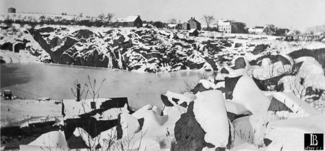
“No one living can possibly recall when Flat Ledge quarry in Rockport on the west side of the arched bridge was actually just a flat ledge running down to the rocky shore. Now it is a 140-foot deep hole in the ground and it measures about 1100 feet in diameter.” Barbara Erkkila, Gloucester (Mass.) Daily Times, Friday, July 20, 1956.
These two lead sentences to Barbara Erkkila’s newspaper column titled “John Caffrey Recalls 75 years of Granite,” are worthy of careful reflection on our part. Firstly, ‘Flat Ledge quarry’ refers to its geographic location in Rockport on Cape Ann. The quarry itself was known as John Swan’s Pit. Not only was John Swan the foreman of the quarry operation, the biggest derrick was also know simply as “Swan.” A granite cutter only needed to hear the word “Swan,” be pointed once in the proper direction, and they would know where they were expected to gather for work.
Secondly, look how carefully Barbara Erkkila has gauged the size of the quarry, providing us with both depth and diameter.
As she readied for her book, “Hammers on Stone,” she walked and measured the depths and dimensions for all the quarries on Cape Ann. Drew outline maps of the shapes of the quarries.
(In the quarrying world of Barre, VT. we are viewed as Flat Landers; on occasion, in the 19th century, when work got slow in Barre, granite cutters would walk down to Rockport, but soon grew weary of the cold winter sea air and would return back inland.)
… and so some 70+ years on from Barbara’s 1956 article, with but a hint of the historic, daily life of the working quarry cutters left, we mumble and stumble politely commenting and turning over the same mis-information, time after time. We speak English so well in our earnest efforts to connect with this massive granite. Granite is amongst the hardest of rocks, and it is the most forgiving of rock. May we forgive our inaccuracies.

[Flat Ledge Quarry, 1935. Five years after the water pumps have been stopped forever, we can see the water in John Swan’s Pit has risen to levels we are accustomed to viewing. This photo is taken from the Pigeon Cove side of the Keystone Bridge. The much debated water tower is visible atop Pigeon Hill – the Hill still being mowed in the summer, it is not yet covered by the tree growth and brush we now know. Along Rowe Ave, derelict paving cutter sheds dot the right edge of the horizon line. Photo courtesy of the SBHS.]


